A survey of Cultural Mapping in Roper River and Gulf of Carpentaria 1996-2024 by Simon Normand in collaboration with elders of SE Arnhem Land

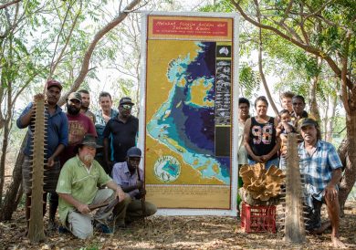
Thomas Farrell, Walter Rogers, Gordon John Forrest (dec) with Simon Normand, Ngukurr Art Centre 2023. Photo with permission of family.
All Together We Hold That Country – NO Means NO!!
This landmark exhibition brings together 11 maps created by Simon Normand in collaboration with elders of SE Arnhem Land over 28 years. They are being shown collectively for the first time. The maps began as a cultural preservation project and now have become critical tools in articulating the concerns of Traditional Owners about the impacts of water extraction in the region. The First Nations people of the region are asking for the Roper River to be protected and NO MORE WATER to be extracted or water licences issued for the catchment. They fear for the future of life for all sentient beings in the region. NB: The maps on exhibition are not for sale.
Project Origins: The project of mapping started in 1996 in response to requests from elders. Maureen Thompson and Marra elders wanted the oral histories of their country recorded visually for their grandchildren before they passed. Simon began mapping as a way of understanding and communicating, from a non-Indigenous perspective, how Roper and Gulf country mob saw and felt about country. The map project is ongoing.
Language groups: Marra/ Wandarrang/Ngandi/ Ngalakan/ Alawa/Wagilak/ Mangarrayi

Saltwater map at Limmen fishing camp with Mara and Yanyuwa elders 2017
Communities involved: Numbulwar, Limmen, Borroloola, Ngukurr, Urapunga, Minyerri and Jilkminggan
The main map: The largest map of Roper River Songlines is 13m long and took over 100 hours to paint after seven field trips 2023-2024. It traces the catchments and journey of the might Roper River from its origins in Mataranka over X km to the Gulf of Carpentaria. As it enters the Gulf the flow of freshwater sustains the largest seagrass meadows in the Southern Hemisphere. This map was done after the completion 1996-2022 of the other 10 maps of country broadly covering the Roper catchment. Over 250 people helped collaborate in its production. The original map will be displayed during the opening and a copy of the map will be on exhibition throughout.

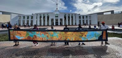
Roper River delegation to Canberra to present their Songlines map to the Australian Parliament November 2023.
The Roper River map journey thus far: The Roper River Songlines map and elders went to Canberra in 2023 to present the map to Federal Parliament and asked that no more water be extracted from the catchment. The visit included talks and a performance. Elders all along the Roper/Ngukurr/ Minyerri/ Numbulwar expressed no faith in the NT Government’s willingness to protect their river.

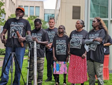
Clive and Roland (Numbulwar songmen), Simon Normand, Naomi Wilfred (Alawa elder), Rosina Farrell (Jilkminggan elder) and Daphne Daniels (Ngukurr elder) before Songlines performance at Parliament House November 2023.
The artist: SIMON NORMAND is a sculptor, printmaker, painter, photographer, author and environmentalist. He has lived and worked with elders in southern Arnhem Land for over 30 years and has worked with Marra, Alawa, Yanyuwa, Warndarrang, Nunggubuyu, Waagilak and other elders to paint maps which show local cultural knowledge and stories for Country. His on-going cultural mapping projects in collaboration with the Ngukurr community on the Roper River document a long time connection with the landscape of the Northern Territory and the first peoples who still intimately hold on to one of the most remote and unknown (by non-Indigenous peoples) parts of Australia.
Simon has visited the region over 50 times since 1996 and spent three years living in Ngukurr community
Media: The project has been documented by the Age/ ABC and Nikkei Asai. To date the story of the Roper River Songlines map travelling to Canberra has been viewed by more than 20 million people worldwide.
Acknowledgements:
The Roper River Songlines map production and trip to Canberra in 2023 was funded by Pew Charitable Trust 2022-2023.
Elders will be travelling to the exhibition opening on 17th August with the support of the Federal Government Regional Arts Fund.
Songlines receives philanthropic support from John Clark.
